IRAN UNESCO WORLD HERITAGE SITES
UNESCO World Heritage is the name of an international treaty ratified by the UNESCO General Conference in 1972. Its subject is the preservation of human historical, natural and cultural monuments of international importance and no longer belong to a single country alone, but to all human beings on earth, regardless of race, religion or nationality. According to the convention, UNESCO member states can nominate their country for historical, natural and cultural monuments as a World Heritage Site. The protection of these works after registration is not limited to that country, but all members are obliged to do so. These sites can include all natural and man-made areas, including forests, mountains, deserts, tombs, buildings, complexes, or cities, and each country can only apply for one UNESCO World Heritage Site each year. iran has one of the largest numbers The UNESCO World Heritage sites in the world with 24 historical and cultural sites that have been registered in the UNESCO World Heritage.
CHOGHA ZANBIL

Dur Untash Ziggurat, better known as Chogha znabil, is actually an ancient shrine that dates back to around 1250 BC in the Elamite civilization. This ziggurat is the central building of the ancient site left over from the Elamite Duravantash complex, which is located near the city of Shush, which is now in Khuzestan province. Chogha znabil is the first World Heritage Site of Iran, which was included in the UNESCO World Heritage List in 1979, and its special and unique architecture, along with the ziggurats discovered in the middle of Iran, namely Dez and Karkheh rivers, for archaeologists and those interested in world history and cultural heritage. Choghaznabil was the only known example of this type of building in Iran before the discovery of the ziggurats along the Sandal and Silk hills. Orientalists consider Choghaznabil to be the oldest known religious building in Iran.
PERSPOLIS
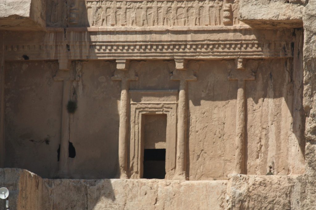
Persepolis or Parseh is the name of one of the ancient cities of Iran, which has been the glorious and ceremonial capital of the Kingdom of Iran during the Achaemenid Empire for more than two centuries. In this ancient city, there is a palace called Persepolis. On the first day of the new year, which is the beginning of spring (February 21), many groups from 24 different countries that were under the Persian Empire on behalf of their country or the governorates with various gifts in Persepolis. They gathered and presented them to the Shah and returned the celebration of Nowruz
In 518 BC, the construction of Persepolis began as the new capital of the Achaemenids in Persia. The founder of Persepolis was Darius the Great, but after him his son Xerxes and his grandson Artaxerxes I expanded the complex by adding other buildings. Much of the information available about the history of the Achaemenids and their culture is due to the inscriptions and inscriptions engraved on these palaces and on its walls and tablets. It is estimated that the Persepolis plain, which included 39 settlements, had a population of 43,600 during the Achaemenid period. Historians believe that the Greek general Alexander the Great invaded Iran in 330 BC and set Persepolis on fire, possibly destroying much of the Achaemenid culture, art, and culture. However, many artifacts from this huge collection have survived. With the most valuable ancient site in Iran since 1979, it is one of the UNESCO World Heritage Sites.
NAQSH_E JAHAN SQUARE
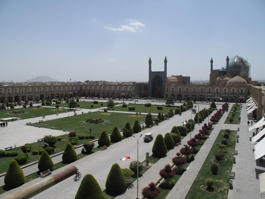
The third largest square in the world after Tiananmen, Beijing and Moscow Red Square, Naghsh_e Jahan Square is also known by the historical name of Shah Square and after the 1979 Iranian Revolution with the official name of Imam Square, the central square of Isfahan, which is located in the heart of Naghsh Jahan historical complex. . The historical monuments on the four sides of Naghsh Jahan Square include Aliaqapo, Shah Mosque, Sheikh Lotfollah Mosque and Qaisaria Gate, which is the main entrance of Isfahan Bazaar. In addition, there are two hundred two-story rooms around the square, which are generally the place of supply of Isfahan handicrafts.
Before the city of Isfahan was chosen as the capital of Iran in the Safavid era (16th century), there was a large garden called Naghsh Jahan in this square. The garden was also the site of government buildings and palaces of former rulers such as the Timurids and the Aghquyunlus. At that time, the field part of the garden was called “Dar Kushk”. This section was located on the western side of Naghsh Jahan Square today and at the construction site of Aali Qapo Palace. During the Seljuk period, there was at least a part of Naghsh Jahan Garden called “Kushk” Square. Some official rituals have been like Nowruz celebrations.
Since the beginning of the reign of Shah Abbas I, the surface of the square has been leveled to a much larger size than the former Kushkak Square, and lighting and fireworks have been held in it many times. Two of the most famous architects of the Safavid era are Mohammad Reza and Ali Akbar Esfahani who designed the square and built it in its current form. The names of these two prominent architects can be seen on the entrances of the buildings around the square
TAKHT_E SOLEYMAN
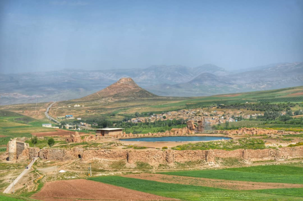
Takht-e Soleiman historical site is located in West Azerbaijan province, at a distance of about 45 km from Takab city. The historical site of Takht-e Soleiman is located in a village of the same name, which includes works such as Suleiman Prison, Suleiman Lake, Anahita Temple, Azar Goshnasp Fire Temple, halls and capitals, each of which has a historical narrative. The ancient city of Shiz has been based on evidence and documents in this area. Which has been destroyed by volcanic activity. Takht-e Soleiman Takab Lake is a mysterious lake with many legends and stories.
The ancient and historical building of Azar Goshnesp fire temple is the remnants of a mysterious place of worship from the Sassanid era. This fire temple was known as Solomon’s throne in local and indigenous beliefs and was attributed to the prophet Solomon. This belief was formed from the Safavid era. Azar Goshnasp Fire Temple is one of the three famous and important fire temples in Iran and the most important fire temple in the northwest of the country. Suffice it to say that this fire temple was the largest educational and religious center of Zoroastrian monotheism in the pre-Islamic period.
According to historical documents and texts, every king who ascended the throne must have come to this fire temple for worship at the beginning of the kingdom. The location of this fire temple was so high that it also had a share of the spoils of war, so that huge treasures of those spoils were in this fire temple. Perhaps this caused its destruction after the defeat of Khosrow Parviz in the war with Heracles. That great treasure was looted by the army of Heracles and then the building of the fire temple was destroyed. This fire temple was almost abandoned with the arrival of Islam and the Arab invasion of Iran, so that during the Mongol era, one of the elders of this people has evidence that Hala ku khan was a nephew.
BAM AND ITS CULTURAL LANDSCAPE
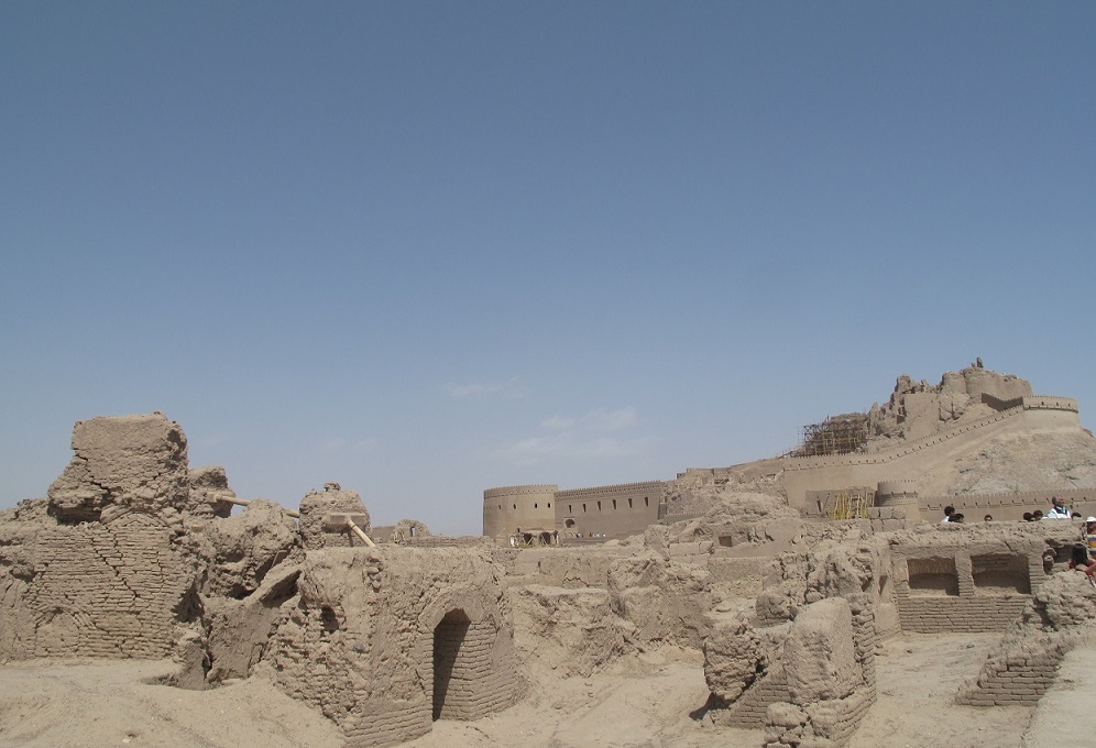
It is impossible to talk about the southeast of Iran and not say anything about the historical citadel of Bam. Bam is the name of one of the historical cities of Iran and Kerman province, so if they want to show a tourist two or three historical photos of Iran, one of them is Bam Citadel. Bam Citadel is the largest brick building in the world, which is compared to the Great Wall of China in terms of grandeur and beauty. The city of Bam is located approximately 1200 km from the capital, this city is world famous for its history and agricultural products, especially dates. The old city of Bam was once part of the Persian province and was known as the gateway to eastern Iran. Bam was at a critical juncture in the history of Lotfali Khan Zand’s reign when he decided to flee Bam. It was even declared the capital of Iran by Lotfali Khan and was the capital of Iran for some time.
Some tourists who have visited Bam in the past have said that this city is a bazaar and attracts people from a distance, and the fabric produced here is famous in many countries, and Bam’s reputation throughout the Islamic world is complex and the country’s pride. And most of the residents of the city are weavers and most of Bam’s export garments are provided in a large village near it. In the east and west of the Islamic world, these garments are considered to be the highest of all garments. Merv comes out and is produced in Bam. It is said that silkworm breeding and several silk weaving workshops have started in the Yazd, Bam, Shushtar and Khuzestan regions since the sixth century AD, and it is very likely that the textile industry is older in the Bam region. The information of the inhabitants of the first Bam is not well known, but from the mass settlements, especially the construction of strong towers and fortifications around them, it can be assumed that this is an Aryan culture because the natives of Iran did not consider such fortifications necessary according to the conditions of that time. The continuous residence of the people in the citadel from the last millennia to 150 years ago can be assumed that the current people of Bam are of relatively Aryan descent. Also, some time ago, a researcher’s research on the people of Dehbakri and its subordinate villages and their experiments showed that the DNA of the people of Dehbakri and its functions are the same as the DNA of corpses buried in Bam citadel, and this means that the people of Dehbakri and its functions are the same. The old people are the citadel of Bam who hundreds of years ago for unknown reasons such as drought or hot weather, etc .. Over time and over the years from the citadel of Bam have moved to this watery and pleasant area, most of them in the same citadel Remaining. The construction of this old city is mentioned in Persian mythology, especially Ferdowsi’s Shahnameh
PASARGADAE
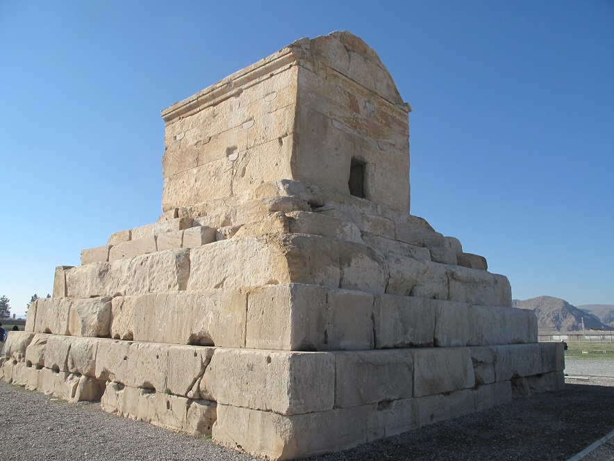
Pasargad World Heritage Site is a collection of ancient structures left over from the Achaemenid period, which is located in Pasargad city in Fars province. This complex includes buildings such as the tomb of Cyrus the Great, the royal garden of Pasargadae, the palace gate, the bridge, the public palace that can be called the first UN, private palace, pavilion, fountains of the royal garden, Cambyses tomb, Tal Takht defense structures, Mozaffari caravanserai, It is a sacred site and a rhetoric.
This collection is the fifth registered in the list of World Heritage Sites in Iran, which was registered in the UNESCO World Heritage List in July 2004 in China due to its many characteristics with 100% of the votes in the World Heritage List.
Pasargad region is located in a high plain at an altitude of 1900 meters above sea level, in a mountain fence that has a unique position. In the seventh century, a local ruler built a mosque near the tomb of Cyrus the Great, in which palace stones were used. On the occasion of the 2500th anniversary of the Iranian Empire in 1971, these stones were returned to their original places. The residence palace undoubtedly shows the influence and role of Greek architecture. It seems that when Cyrus conquered Sard (the capital of Lady, a city in western Turkey today) in 545 BC, he was greatly influenced by the marble buildings of the Lady kings. He may have employed a number of Lady professors in Pasargadae at the same time. In the palace of attractive proportions, dark and light marble stones, especially in the foundations, attract attention. These stones have been brought from around the city of Marvdasht. Pasargad plain is located in the northern part of Fars province and between the Zagros Mountains, 130 km north of Shiraz. The average height of the plain above sea level is 1850 meters, which covers an area of about 190 square kilometers. The only statue of Cyrus the Great is in this valuable collection.
SOLTANIYEH

The dome of Soltanieh is the tomb of Oljaito, which was built by his order between 1302 and 1312 AD in the city of Soltanieh, which was the capital of the Ilkhanids, and is considered one of the important works of Iranian and Islamic architecture. From the dome, for example, in the basement. Soltanieh is the largest brick dome in the world and this building is the third largest dome in the world after the dome of the church of Santa Maria del Fiore, and the dome of the Hagia Sophia and this dome is the first double-walled dome in the world that can not be found in the world. The height of the dome is 48.5 meters, the thickness of the dome is 160 cm and the empty space between the two shells is 60 cm. The dual wall system of the dome can be investigated in relation to static issues. Due to the high resistance of the building in bending and shear anchors, it has made it hollow and invulnerable to the earthquake. Although some prominent architects in the world have expressed similarities to the dome of the church of Santa Maria Del phiore de Florence, but it must be acknowledged that this beautiful brick building with its dome never bears the slightest resemblance to other domes in the world and basically the structure of Soltaniyeh dome has its own unique feature. This is probably one of the most important reasons for the global registration of this building.
BISOTUN
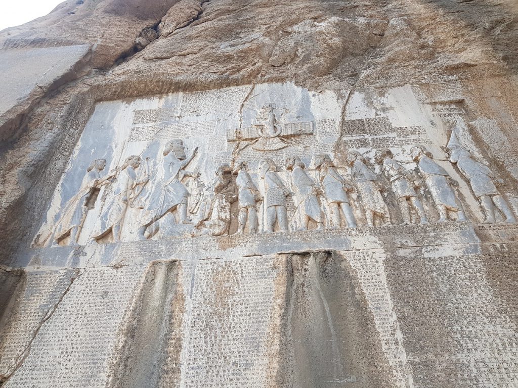
Bistoon inscription is the largest inscription in the world, the first known Iranian text and one of the works of the Achaemenid dynasty (520 BC) located in Bistoon city of Harsin city, 30 km from Kermanshah, on the slopes of Bistoon mountain. The Bistun inscription is one of the most important and famous documents in the history of the world and the most important historical text in the Achaemenid period, which shows the victory of Darius the Great over Gomatus the Magi and the imprisonment of the rebels.
The Biston site is a national monument of Iran, and this monument itself has been one of Iran’s UNESCO World Heritage Sites since 2006.
The Bistoon inscription was built at a height of a few tens of meters above the ground and on the southern slope of Mount Prao, and the remnants of a staircase at the top of Mount Biston are thought to have been used by stone masons to reach the inscription site. From the end of the work, the stairs have been cut in order to make the effect inaccessible. The Biston inscription is created on a limestone rock, which, based on the brown glaze that covers the surface of the inscription, as well as the lead residue seen in the first few lines of the work, appears to be a full-length work at the end of the work. It is covered with an unknown lining.
The relief, like many other Achaemenid inscriptions, is written in three languages
The first Elamite narration on the four pages on the right
Akkadian narration on a long boulder on the left
Ancient Persian narration is embossed in the following four pages
The second version of the Elamite narration in three pages following the Akkadian narration, in 518 AH. They have since added that adding the role of a rebel to the first Elamite tradition has been damaged.
Adding the fifth piece to ancient Persian after adding insurgent images
ARMENIAN MONASTIC ENSEMBLES OF IRAN
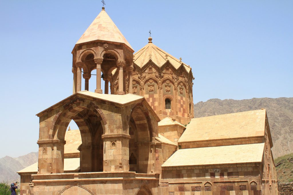
The Armenian Monastic Ensembles of Iran is a collection of three Armenian churches (Qara Kilisa, St. Stephen’s Church and chapel of Dzordzor ) located in the provinces of West Azerbaijan and East Azerbaijan. These churches were founded between the seventh and fourteenth centuries AD and have been rebuilt several times over time.
On July 8, 2008, the collection of Armenian churches in Iran was inscribed on the UNESCO World Heritage List.
The complex of Armenian churches, the buildings around these churches and the village of Darreh Sham are among the elements of cultural exchange between Byzantine Orthodox culture and Iranian culture. These churches, which were located at the southeastern tip of the Armenian culture, became the center of the spread of this culture in Azerbaijan, Iran, and are still in good condition in terms of health and authenticity.
Qara Church (St. Thaddeus Church or Tatavus Church) is the second oldest church in the world and one of the most prestigious and painted Armenian churches, consisting of two old black sections and a new white section. This church, which was built on the tomb of St. Tatavus from the 4th to the 6th century AD, has a great religious value for the Christians of the region as well as the Armenians of the world. The Church of St. Stephen (Church of St. Stephen) is one of the most important Armenian churches in Iran after Qara. This church belongs to the 10th to 12th centuries AD. The whole grounds of this church are located in the heart of the mountains and are especially respected by the followers of other religions. In fact, this church belongs to the Gregorian Christian branch, most of whom live in Armenia.
Zor Zour Church (Church of the Blessed Virgin Mary) is the third most famous church in the world list of Armenian churches in Iran. This cruciform church belongs to the year 1298 AD.
Darreh Sham village is also registered in the list of Armenian churches in Iran because it is an Armenian village and has special customs. There are eight churches and shrines in the Sham Valley area, including the Upper Holy Church next to the Sham Valley Armenian Cemetery, the Church of St. Sergius in the Middle Sham Valley, the Church of St. George in the Upper Sham Valley, and the Shepherd Church He pointed to the way of Jolfa dinner valley.
SHUSHTAR HISTORICAL HYDRAULIC SEYSTEM
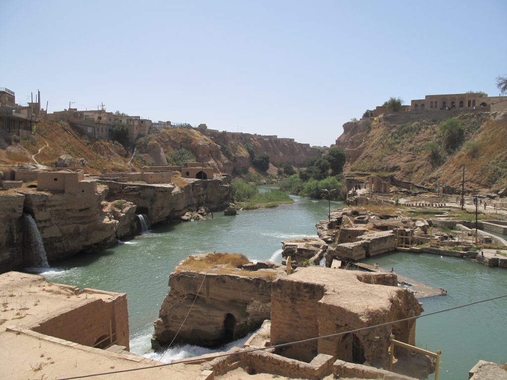
The historical water system of Shushtar is an interconnected set of 13 historical monuments including bridges, dams, mills, waterfalls, hand canals and huge water conduction tunnels that work in connection with each other and were built during the Achaemenid to Sassanid eras to make more use of water. . Since the inhabitants of the Iranian plateau have always faced the problem of water shortage, they always tried to solve this constant problem with the genius of Iranian architects and engineers, and the water structures of Shushtar are one of the best examples of this claim. In the travelogue of Madame Jean Diolafois, the famous French archaeologist, this area is mentioned as the largest industrial complex before the Industrial Revolution. These 13 historical monuments are located a short distance from each other in the city of Shushtar, which has been registered as the tenth Iranian monument in the UNESCO World Heritage List as the historical water system of Shushtar.
The complex of waterfalls and water mills is the largest and most visited part of the historical water system of Shushtar. There are a significant number of water mills in this ancient complex and a complete and large example of using water power to rotate the mills can be seen in it. This collection is one of the most unique examples that has been used for the optimal use of water in ancient times, which is located next to the important river of southwestern Iran, namely Karun.
TABRIZ HISTORIC BAZAAR COMPLEX
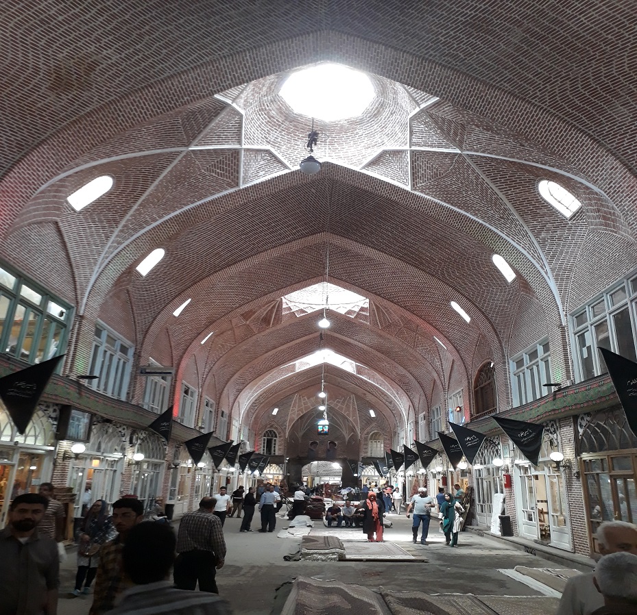
Tabriz Bazaar is the largest and most important indoor market in the world, which is located in the city of Tabriz in Iran. With an area of about one square kilometer, this market is the largest indoor market in the world. Tabriz Bazaar has been registered in the UNESCO World Heritage List in August 2010. This market consists of numerous bazaars, corridors, timchehs, inns and caravanserais. In the past, due to the location of the city of Tabriz at the crossroads of the Silk Road and the daily passage of thousands of caravans from different Asian, African and European countries, this city and its market has enjoyed a very prosperous.
This bazaar was rebuilt about 3 centuries ago and after the occurrence of the historic earthquake in Tabriz in 1193 AH by the then ruler of Tabriz. The date of construction of this complex is not known; But many tourists who have visited this market from the fourth century AH to the Qajar period have provided information about it.
Many tourists such as Ibn Battuta, Marco Polo, Jackson, Chalabi parents, Yaqut Hamavi, Gaspar Drewville, Alexis Soktikoff, Jean Chardin, Eugene Flandin, John Cartwright, Jamli Cardi, Clavijo, Robert Grant Watson, and Hamdallah Mastoog And have glorified the glory of Tabriz Bazaar. This bazaar with about 5,500 rooms, shops and stores, 40 types of jobs, 35 houses, 25 Timchehs, 30 mosques, 20 rows and bazaars, 11 corridors, 5 Baths and 12 schools are known as the main center of trade between the people of Tabriz and Iran.
Timcheh Mozaffari or the carpet sales section of Tabriz Bazaar is one of the most beautiful sections of this market that shows the pure art of carpet weaving of the people of Tabriz and its surroundings as well as an art exhibition with a good audience.
THE PERSIAN GARDEN
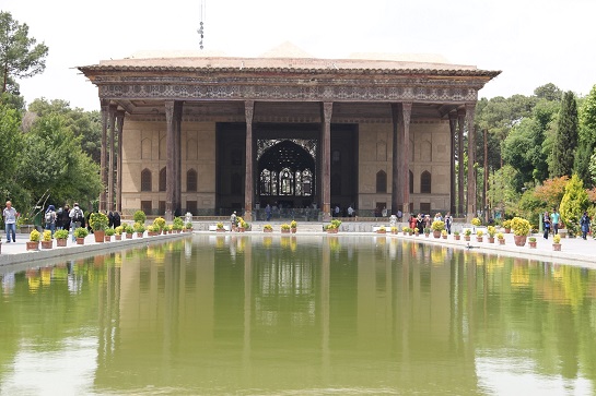
Persian garden is a garden that based on its architecture and constituent elements such as geometric structure, water and trees and middle pavilion, etc., has been prevalent mainly in the Iranian plateau and surrounding areas influenced by its culture.
In Iranian literature, the Persian garden is called “Baghsara”, Pardis or Ferdows, which found its way from Persian to Latin, as well as Bustan or Bostan, and it can be said that the word “Persian garden” is not very old.
The Persian garden has three unique structures and designs: First, it is located in the path of water and water. Second: It is surrounded by high walls. The third is inside the garden of the summer mansion and the water pool. These three characteristics distinguish Iranian gardens. In fact, the Iranian gardeners who observed it described the Iranian gardeners as “Persian Garden”. The Persian garden or “garden house” refers to its unique structure and design. The Persian garden is connected with the history of the origin of the aqueduct. The first Iranian gardens were formed in the way of the aqueducts. Examples of such gardens can be seen in Tabas, Yazd, Gonabad, and Birjand and most desert areas. One of the characteristics of the Persian garden is the passage of water inside the garden, which usually had a swimming pool in the middle of the garden and a summer house or building. Some gardens are in the form of four gardens and the water passes in 4 directions, which can be seen in the Homayoun shrine in Delhi, the capital of India, which is completely influenced by the Persian garden.
The Persian garden of Pasargad complex is considered to be the root of the architecture of these gardens. Cyrus the Great had personally ordered how the garden of Pasargadae would be created and how the trees would be planted, and in fact the geometry of the garden and its shape and image were taken from the view of Cyrus to the Persian garden. In the Sassanid period, gardens were formed in front of palaces and temples, and this continued in the Islamic period.
The oldest pictorial document depicting the order of the Persian garden dates back to the Sassanid period. In the relief of Taq-e Bostan, the hunting scene of Khosrow Parviz shows his garden-hunting plan in Taq-e Bostan. This relief largely reveals the geometry of the garden and its function.
These gardens, as a complete structure, express the inseparable and deep relationship between the cultural and natural context and are a sign of adaptation and alignment of human and nature needs. Relying on his experimental knowledge, the creator of the garden created an atmosphere that caused the survival and dynamism of the natural bed, especially for Iranians, for whom nature always has a deep meaning, and many celebrations and beautiful gatherings take place in nature.
SHEIKH SAFI AL DIN KHANEGAH AND SHRINE ENSEMBLE IN ARDABIL
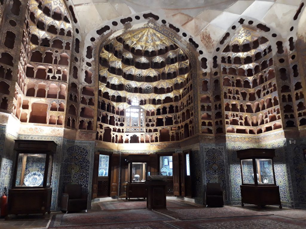
The tomb of Sheikh Safi al-Din Ardabili is one of the historical and archeological sites of Ardabil in northwestern Iran and one of the monuments of Iran in the UNESCO World Heritage List.
In this place, in addition to the tomb of Sheikh Safi al-Din Ardabili, the tombs of Shah Ismail I (the first Safavid king) and the mother of Shah Ismail (daughter of Ozun Hassan Aq Quyunlu) as well as some elders and officials of the Safavid era and the Iranian martyrs of the Chaldoran war The Ottoman army happened to be there. Other parts of this complex are porcelain house, mosque, paradise, monastery, challah house, martyrdom place and lamp house.
Sheikh Safi’s house and monastery are located in the same place, and according to the sheikh’s will, his body was buried in a room next to the private house, garden and pool house, and a building was built on his grave, in addition to the tomb of Sheikh Safi and the shrine of Shah Ismail I – tombs Place another Safavid prince and his children in this tomb and the place of martyrdom. The exquisite collection of the tomb of Sheikh Safi al-Din named after the famous mystic Sheikh Safi al-Din Ardabili, the ancestor of the Safavid dynasty sultans, was built in 735 AH by his son Sadr al-Din Musa. After the beginning of the Safavid rule, due to the devotion of the Safavid kings to their ancestor, various units were added to this collection. Especially during the reign of Shah Abbas I and since he had a lot of devotion to Sheikh Safi al-Din and visited his tomb a lot, a lot of work was done to complete and decorate this work. In the Safavid era, the tomb of the Sheikh was adorned with the presence of the great masters of the Safavid era, so that after several centuries, it is still considered as one of the historical and cultural monuments of Iran.
It can be claimed that one of the unique cases of this collection is that this tomb contains dozens of original works in different themes of different fields of pure Iranian art, which has been used in this place to a very high degree due to the great devotion of the descendants to their ancestor. And this tomb shines like a jewel in the heart of Ardabil, including the highest type of mosaic and moqarnas tiles and plaster of beautiful and exquisite inscriptions and calligraphy of great Safavid period (Mir Emad, Mir Ghavamuddin, Mohammad Ismail and…) valuable inlays, He mentioned silver work, gilding and gilding, painting and narrowing and so on. This work has a magnificent architectural structure that the combination of the mentioned artistic virtues has made it significant and distinctive in the historical collections of Iran.
During the Iran-Russia wars during the Qajar period and the fall of Ardabil, the manuscript of Sheikh Safi al-Din Ardabili’s library was looted by the Russians. The manuscripts are now housed in the St. Petersburg Museum in Russia. This is a historical monument in Aali Qapo neighborhood
MASJED_ E JAME OF ISFAHAN

Isfahan Grand Mosque, also known as Atiq Grand Mosque and Isfahan Friday Mosque, is one of the historical monuments of Isfahan that dates back to the second century AH and is one of the oldest mosques in Iran. This mosque was built in 156 AH / 777 AD. .
If the evolution of the construction of religious buildings after Islam is important for any audience, this building is the best place to see this evolution and is also a university for students interested in architecture.
One of the best solutions for the Arabs after the invasion of Iran was to build holy places such as mosques on Zoroastrian fire temples that would make it easier for people to believe in the new religion. Isfahan is one of the best examples
A mosque that was built small and in proportion to the population of Isfahan and caused the growth of urbanization in Isfahan. In 226 AH / 846 AD, by the order of Caliph Mutasim Abbasi, the former mosque was destroyed and a columned building was built with a wooden roof, of which part of the columns and walls still remain. But the most important changes in the mosque took place during the Seljuk period; The architects of this period distanced themselves from the pattern of the “Arab Mosque” and by building four porches on the north, south, east and west sides, created a new style known as the “Iranian Mosque”. In the month of Rabi ‘al-Awal in 515 AH, this mosque was set on fire by the Ismailis, which was rebuilt in later periods. In the following centuries and in the patriarchal, Mozaffari, Timurid, Safavid and Qajar periods, this mosque also had important changes.
Isfahan Grand Mosque was originally made of raw clay, but due to the stability of the brick, high construction speed and other factors, brick was used in its reconstruction. Fountain arches, four porches, entrances, brick rafters and various decorations that are used in accordance with the architecture of each period of Iranian history and in Khorasani (or Arabic) and Razi styles in this mosque, have created a work that is a model for Iranian mosques and Even Muslim areas have become different.
GONBAD _E QABUS
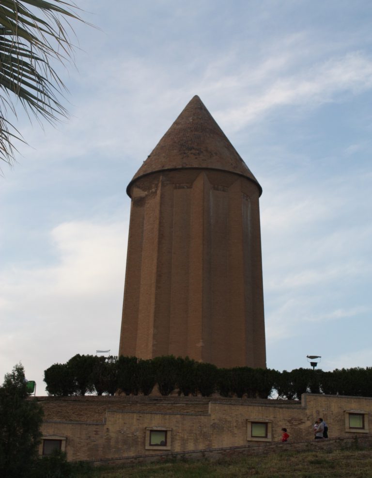
Qabus Dome Tower is a historical building from the fourth century AH which is located in Gonbad Kavous city, northern Iran in Golestan province. The architectural style of the building is Razi style.
The building, which is the tallest all-brick tower in the world and is 52 meters high, is located on a dirt hill that is about fifteen meters higher than the ground. The height of the building with its foundation is 72 meters and can be seen even from very long distances of about 15 kilometers. This building was built in the tenth century AD and has remained stable for more than a thousand years. Which was the capital of the kings of Al-Ziyar in that land, has been built and can be said to be one of the most magnificent monuments of the north and northeast of Iran.
Below the eastern side of the Alborz Mountains and in front of the vast deserts of Asia, one of the greatest architectural masterpieces of Iran has risen in all its glory and grandeur. This building is the dome of Kavous, the tomb of Kavous bin Vashmgir and the tower of the tomb is far from any arrangement of greetings. A fighter with the power of faith in a face-to-face battle, the poet’s kingdom in a battle with eternity, is there such a large and powerful tomb?
Shams al-Ma’ali Qaboos bin Vashmgir has built this building for his personal tomb
GOLESTAN PALACE
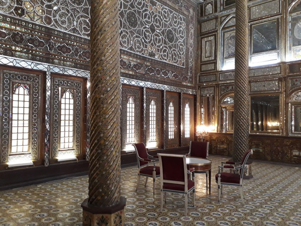
Golestan Palace is one of the most unique historical complexes in Iran with a history of 440 years. The name of Golestan to this complex is rooted in the foundation of a hall called “Golestan” which is one of the buildings of the era of Agha Mohammad Khan Qajar and ends in 1216 AH and in the era of Fath Ali Shah Qajar.
Golestan Palace is one of the most important places for the coronation of the kings of the last three centuries in Iran, the last of which was the coronation of Mohammad Reza Shah Pahlavi in 1967. It is easy to see the evolution of the architecture of the government centers of Iran in the last 3 centuries in this palace, and in addition, the very exquisite objects inside the palace, especially in Salam Palace, have multiplied the importance of this palace. It has undergone changes from the Safavid era to the contemporary era. Although the foundation of Golestan Palace dates back to the time of Shah Abbas Safavid and in 998 AH and with the construction of four gardens inside the fence of Shah Tahmasb and later during the reign of Shah Suleiman Safavid (1109 – 1078 AH) with the construction of a court house in the same The area of Shah Abbasi Chenarestan is formed, but today there are no traces of those foundations; And the existing assets of Golestan Palace in terms of longevity are limited to some of the monuments and buildings from the Zandieh era and do not go beyond that.
Golestan Palace was registered as a UNESCO World Heritage Site on July 2, 2013, at the 37th Annual Meeting of the UNESCO World Heritage Committee in Phnom Penh, Cambodia, and is arguably the only World Heritage Site in Tehran.
SHAHR_E SOKHTA

Sokhteh is the name of the remains of an ancient city-state in Iran. It is located 8 km from the new city of Ramshar and 30 km south of Mohammadabad, the center of Hamoon city, on the Zabol-Zahedan road in Sistan and Baluchestan province. It coincides with the civilization of Jiroft in the province of Sistan and Baluchestan in Iran. The city was built on the banks of the Helmand River and Lake Hamoon, along the current Zabul Road. Colonel Beit, one of the British military officers, was one of the first people to mention this area during the Qajar period and after visiting Sistan. It is a fire. After him, Sir Orlstein visited the site in 1937 and provided useful information about the site. The burnt city has been studied and excavated by Italian archaeologists under the supervision of Martiso Tuzi from 1346 to 1357. Since then, the Sistan Cultural Heritage, Handicrafts and Tourism Organization has been responsible for exploring this mound until today.
The invasion of neighboring invading tribes and the diversion of the Helmand River have been cited as the most important reasons for the decline of the burnt city civilization. Contrary to popular belief, there were no fires in the city. There is not even evidence of software warfare in the burned city. Burnt City was an industrial civilization; Thus, many kilns were operating, the ashes of which were dumped around the residential area. Also, in the post-civilization period in this region, nomadic peoples dug up the earth and lit fires to prepare food. Under these conditions, the first archaeologists, when they visited the area, noticed that there was a large area of ash; So the first nickname they gave it was the burnt city. What is rippling in the burnt city is expertise, solidarity, friendship and peace, and there has been no war. Many valuable objects found in the National Museum of Tehran can be seen, such as the world’s first animation on an earthenware vessel or even the world’s first artificial eye found in the burnt city are just some of the features of this area.
CULTURAL LANDSCAPE OF MEYMAND
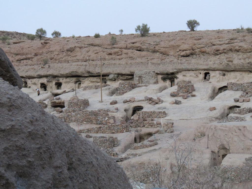
Meymand is a rocky village with several thousand years old, reminiscent of the days when humans sought their gods in the mountains and the mountain was known as a sign of strength, power and stability and will. This ancient handicraft is undoubtedly one of the first human settlements in Iran, a time when Iranians were still pious and considered the mountains sacred. In any case, a few thousand years ago, humans tore open the hearts of the stones and left a monument that today, after many years, is still a symbol of the determination and authority of the Iranian ancestors. No one still knows exactly who created this complex and what motivated these people to build such buildings.
Two theories have been proposed regarding the emergence of Meymand underground structures:
First, the Meymand complex was created by a group of Aryan tribes in the eighth and seventh centuries BC, at the same time as the Medes, who have left numerous architectural relics in western Iran. It is also possible that the Meymand rock formations were the result of the beliefs of the Mehr religion, because one of the pillars of this religion is based on the invincibility and immortality of phenomena, and this belief has led them to the sanctification of mountains. They have practiced sectarianism and implemented their religious beliefs in the architecture of their settlements.
Meymand Shahrbabak probably belongs to the second and third centuries AD. During the Parthian period, nomadic tribes migrated everywhere in the southern part of Kerman. These tribes were not completely displaced during the Parthian period, and in the late Parthian and early Sassanid periods, they chose to live in pleasant climates. The existence of a place called Meymand Fortress, in which more than 150 circular stone rooms have been built, which were crypts for placing the dead, reinforces this theory because, considering the location of these masters, it seems that the cemetery belongs to the Sassanid era. Because according to the tradition of that time, the tombs were built in mountainous areas away from the city and the place of residence.
In any case, Handmade Meymand village is known as one of the most significant attractions in Kerman province in central and southern Iran.
SUSA
Susa, located in the province of Khuzestan, is one of the oldest known settlements in the world, probably founded in 4000 BC, although the first traces of a residential village in it date back to 7000 BC. According to ancient documents, Susa was one of the most important and glorious ancient cities of Iran and the world, and archeological activities continue there.
This ancient city along with the tomb of Daniel the Prophet and under the name of the tomb of Daniel the Prophet / the city of Susa and the adjacent hills is one of the oldest discovered monuments in Iran and the existence of three ancient sites and world heritage in this part of Iran Khuzestan.
The plains of southwestern Iran are one of the most important regions that were considered in the study of the mechanism of formation of the first states and even many experts based on numerous ancient monuments and fertility of this region believe that Mesopotamia can be somewhere between the two main rivers of Iran in these areas, Karun And be Karkheh. From the late Neolithic and early Mesolithic periods in southwestern Iran, there is evidence of the construction of canals to transfer water from rivers to agricultural lands. Such projects led to economic development as well as social changes, including division of labor and hierarchy. Houses built on Chaghamish Hill One of the houses is significantly larger and more well-built. The building had mud foundations, very thick rafters, and a special exterior.
About 7,200 years ago in this area (known as the Old Suziana period) there were villages with two to three social classes whose leaders and those around them lived in larger sections and others in smaller places. Violent clashes broke out between the villages as the leaders of these villages sought to expand their sphere of influence, and the victorious side set fire to the settlement of the defeated side. An example of this is Chghamish, whose area reached 17 hectares during its heyday. Chaghamish was destroyed in a regional battle, after which Susa emerged as the center of the region and was chosen as one of the most important summer capitals of the Achaemenid Empire.
THE PERSIAN QANAT
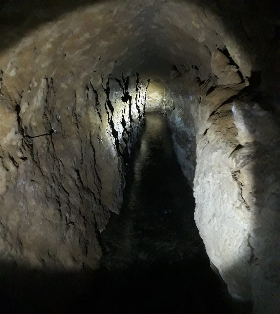
Qanat or canal is a waterway or canal dug underground to allow water to flow to the surface. This channel in the depths of the earth is to connect the strings of wells that originate from the mother of the well. Mother wells are usually an underground spring. Aqueducts are used to direct and manage water for agriculture and other purposes. This aqueduct canal may be several kilometers to reach the ground and is called the outlet of the mouth of the karez or the head of the aqueduct or the mouth of the well. Since there has always been a shortage of water on the plateau of Iran throughout history, Iranians have always sought to solve this great problem through various solutions, of which the aqueduct was one of the most engineered solutions created by them.
The aqueduct was one of the main sources of water supply and it was these karezes that had the capacity to supply water to the farms of more than 60,000 villages in the country. With the arrival of new technology, deep wells replaced the aqueduct and the use of pump motors gradually became common and covered all regions of Iran. The construction of deep wells without planning caused 90% of the aqueducts to dry out, so that it is not possible to rehabilitate them because digging deep wells has greatly reduced the water level. AD have reached the UNESCO World Heritage List. This world collection is known as the twentieth world work of Iran. According to statistics, the number of active aqueducts is 36,300 and the total length of aqueduct furnaces is estimated at 21,700 km and the total length of aqueduct rods is estimated at 158,268 km. Zarch aqueduct is between 2000 and 3000 years old and with a length of 71 km is known as one of the longest aqueducts in Iran. The deepest mother well is located in Gonabad city called Qasbeh aqueduct, the excavation date of which dates back to the Achaemenid period
HYRCANIAN FOREST
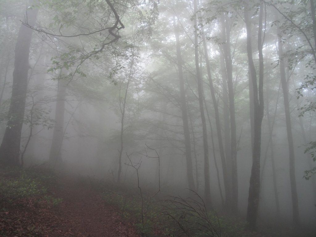
The Caspian or Hyrcanian forests, which are among the temperate deciduous deciduous forests, are an extremely valuable habitat on the southern shores of the Caspian Sea and the northern shore of the Alborz with an area of 55,000 square kilometers (21,000 square miles) (7% of the area of Iran). It is located on the south and southwest coast of the Caspian Sea in parts of the five northern provinces of Iran and is located in the two countries of Iran and the Republic of Azerbaijan. This forest starts from the Hyrkan National Park area of the Republic of Azerbaijan and extends to the province of North Khorasan in Iran, and in Iran, is under the joint protection of the Environmental Protection Organization of Iran and the Cultural Heritage Organization.
The word Hyrcanus is a Greek pronunciation of the name Gorgan. With a history of 25 to 50 million years (Paleogene period), this forest is one of the most valuable and oldest forests in the world and is known as a natural museum and genetic bank. At that time, most of the northern temperate regions of the world were covered with such forests that in the Ice Age, the Quaternary of these forests became smaller, but the moisture from the Caspian Sea prevented these forests from freezing and this valuable area was kept natural for today’s generation. Habitats of many endemic species such as Caspian tit
HISTORIC CITY OF YAZD
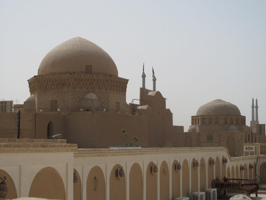
Ancient Yazd, the first brick city and the second historical city in the world, is located somewhere between the Lut Desert and the central desert of Iran, in one of the driest regions of Iran. The predestination of nature has caused the first inhabitants of this city to use their human intelligence and become friends with stubborn nature by creating solutions. This coexistence of man and nature has created a beautiful, unique and purposeful texture as the primary nucleus of Yazd city. Over time, this texture is well preserved and is now known as one of the most valuable historical sites in Iran and the world. The historical context of Yazd, with about 77 neighborhoods and dating back more than 2500 years, has been registered in the UNESCO World Heritage List.
The historical context of Yazd is known as the most untouched and extensive historical residential context of Iran and covers an area of more than 700 hectares. This texture is a unique combination of old back alleys, houses, sabats and brick buildings, all of which have created these facilities for the comfort of residents in the climatic conditions adjacent to the central desert of Iran, where the air temperature reaches up to 50 degrees Celsius. There are more than 1700 historical monuments of Yazd in the traditional and brick texture of Yazd.
Some of the features of the historical texture of Yazd include very dense and compact texture, completely enclosed urban spaces, irregular covered alleys and roofs, connected buildings without distance, placement of biological complexes based on the direction of sunlight and wind. The narrow alleys as well as the high walls are also features of the historical texture of Yazd. The ancient ancestors of the Yazidis raised the walls to provide shade throughout the day, and by winding and narrowing the alleys, they broke the wind speed and protected the citizens from the danger of strong winds. Roofed alleys and sabbaticals were built with the same philosophy to protect the citizens as much as possible from the wind and sun.
SASANID ARCHEOLOGICAL LANDSCAPE OF FARS REGION
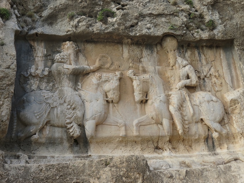
The Sassanid archeological landscape of Fars region is eight ancient sites that are located in three ancient regions, Firoozabad, Bishapour, Sarvestan in the southwest of Fars province which built around 1800 years ago. This work is the twenty-third work of Iran in the UNESCO World Heritage List in 2018
These structures, palaces and cities date back to the early and late Sassanid period, which spread throughout the region from 224 to 658 AD. These sites include the city of Gore, the capital built by the founder of the Sassanid dynasty Ardeshir Babakan, and Bishapour. Archaeological perspective shows the optimal use of the natural topography of the region and is a testament to the influence of Achaemenid and Parthian cultural traditions and Roman art, which later had a significant impact on the architecture and artistic styles of the Islamic era. Other works include the statue of Shapur I (Shapur Cave), the palace of Ardeshir Babakan, Qala-e Dokhtar, the inscription of the kingdom of Ardeshir Babakan and the relief of Ardashir’s victory over Ardavan.
LUT DESERT
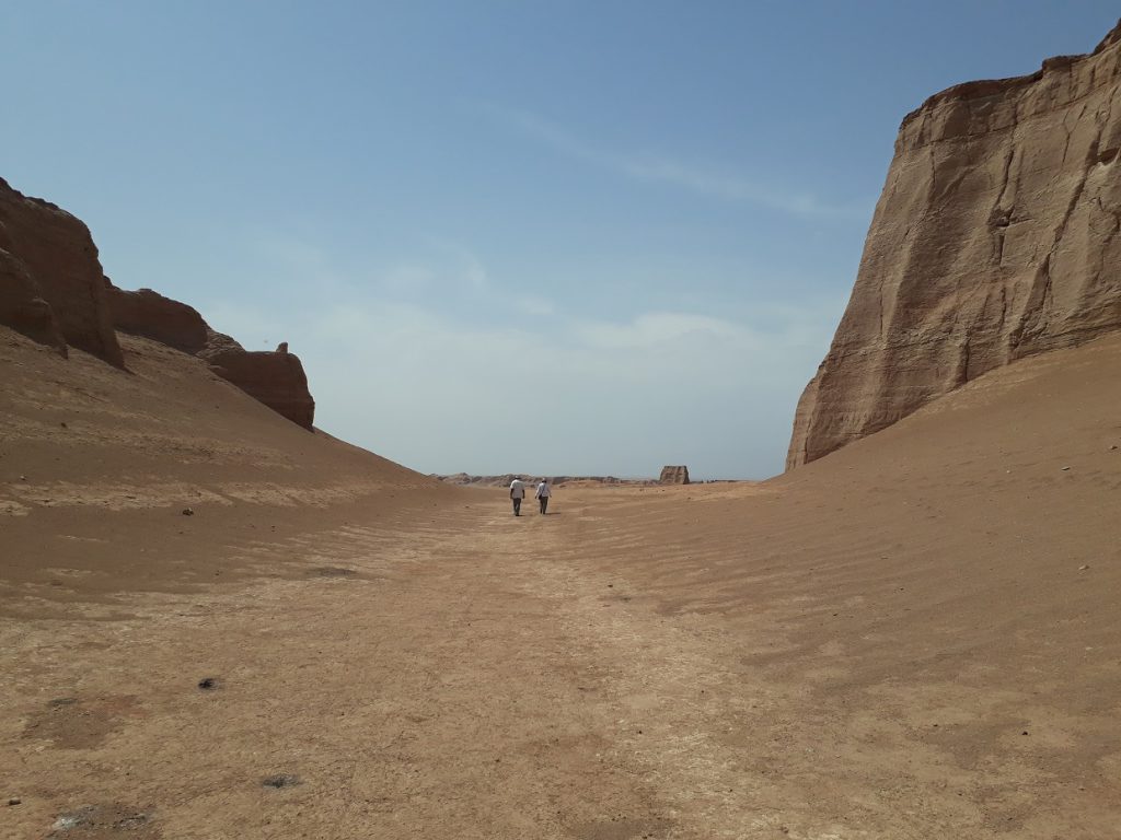
Lut plain is a desert plain in southeastern Iran. This plain is located in the southeast of Iran with an area of more than 40,000 square kilometers (including area and territory) between parts of the provinces of Kerman, Sistan and Baluchestan and South Khorasan and with an area of about 175,000 km, about 10% of the area of Iran. Has included. Lut Desert is the 27th largest desert in the world.
Lut plain is one of the hot and dry regions of the world. Its core was known as the hottest spot on Earth in 2004, 2005, 2006, 2007 and 2009, with the highest recorded in 2005 at a maximum temperature of 70.7 ° C. Scientists have attributed the high heat to the dark color and dryness of its surface, which absorbs the sun’s heat.
The Lut Plain stretches from northwest to southeast. Its length is about 320 km (200 miles) and its width is about 160 km (100 miles).
The World Heritage of the Lut Desert consists primarily of the Lut Desert Yards in the western part, the Yalan Rig or Yalan Citadel in the eastern part, the Hamada in the middle, and the Nebka in the western margin, which make up the entire Lut Desert. Other components of this desert include the Shoor River, the Gandum Briyan region and the Shurgaz Hamoon area. The Lut Desert not only has aesthetic features but also shows part of the processes involved in shaping the region and the history of geology. At the same time, the diversity of landscapes and the unknownness of the region provide suitable conditions for scientific research and the development of geotourism. All these cases, along with the historical civilization of Shahdad, which is inspired by the civilization of Jiroft, have formed a unique complex in the southeast of Iran.
Lut plain is one of the most amazing desert landscapes in the world. Some of its attractions are:
The largest clumsy city in the world. The area of the Klots is remotely reminiscent of large urban ruins that have been described in various ways, such as the imaginary city or the city of Lut.
The highest sand pyramids in the world are in Lut. The tallest known pyramids in the world have a maximum height of 300 meters (Libya), but in Lut, the height of some pyramids sometimes reaches 480 meters.
There are 40 Quaternary volcanic cones on the surface of the Lut Plain.
Extensive areas of sand and gravel with a light brown to gray and black color spectrum, such as “Godar gunpowder”, which is called black because of its black and gunpowder-like soil.
Plains of hollow basaltic lavas such as “roasted wheat”.
Wavy sandy areas
The world’s largest peaks are plant-covered sand dunes, one of the wonders of soil, water and plant coexistence. These nebkas are also called desert vases.
The tallest rods, which are similar to the larger-sized nebkas, are more complex in western Lut.
Areas in the form of multiple polygons that are the result of a thick salt crust and intense evaporation of the earth’s surface.
Hamada or plains of sand, sand and covered with sandy soils that have no vegetation.